Description
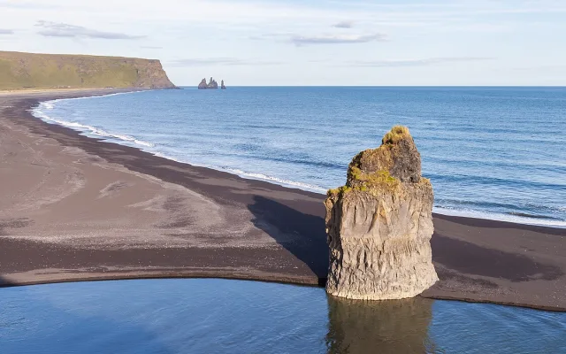
Vik is Iceland's southernmost village, known for the black beach at Reynisfjara, its basalt columns and its puffins.
Wiki
Vik is the southernmost village in Iceland, on the Atlantic coast at the foot of the Myrdalsjokull glacier. Despite its modest size — a permanent population of around 640 — it is one of the most recognisable stops on the famous route along the island's south shore.
The basics
The village's full name is Vik i Myrdal, "the bay in the marshy valley". It sits about 180 kilometres south-east of Reykjavik on Route 1, the ring road that circles the whole of Iceland. That position makes Vik a natural halt for travellers: people refuel here, spend the night and stock up before continuing towards the Jokulsarlon glacier lagoon and Vatnajokull National Park.
The climate here is mild by Icelandic standards but extremely changeable: Vik is reckoned one of the wettest and windiest places in the country. Ocean storms and strong gusts are routine, so check the forecast in advance.
Reynisfjara black beach
The great sight of the area is Reynisfjara, a beach of coal-black volcanic sand. Its dark colour comes from ground-down basalt, the trace of ancient volcanic activity. The beach has repeatedly appeared on lists of the most beautiful shores on the planet.
The key features of Reynisfjara:
- Basalt columns — regular hexagonal pillars formed as lava cooled. They make a kind of staircase at the foot of the Gardar cliff and resemble organ pipes.
- The Reynisdrangar sea stacks — sharp black pinnacles rising straight out of the water near the shore. Icelandic legend says they are trolls caught by the dawn.
- Caves and grottoes in the basalt walls, into which the waves come roaring.
An important warning: Reynisfjara is known for sneaker waves — sudden powerful surges capable of dragging a person into the cold ocean. Entering the water or standing close to the surf line is dangerous; there have been fatalities here.
Puffins and seabird colonies
The cliffs around Vik are a nesting ground for great numbers of seabirds. The greatest draw for visitors is the Atlantic puffin, a small bird with a brightly coloured bill. They can be watched at the Dyrholaey headland, a little to the west of the village. The nesting season runs through the warm months, roughly from late spring to midsummer; during that period access to part of the headland may be restricted to protect the birds.
Dyrholaey is also famous for the huge stone arch reaching out into the ocean — a former volcanic mass punched through by the sea. From the top there is a view along the endless line of black coast and inland to the glaciers.
The village emblem: the church on the hill
Above Vik, on a green hill, stands the small white church of Vikurkirkja with its red roof — one of the most photographed views in southern Iceland. It is understood that in an eruption of Katla, the volcano hidden beneath Myrdalsjokull, the church on high ground would be the refuge for the villagers, since glacial meltwater could flood the lower part of the village.
Nearby
Beyond Vik itself, several notable natural sights of the south coast lie close at hand:
- The Skogafoss and Seljalandsfoss waterfalls — west along the ring road; both are among the best known in the country.
- Fjadrargljufur canyon — a winding gorge with sheer green walls.
- The stony lava fields and glacier tongues of Myrdalsjokull, descending towards the plain.
Practical information
One day is the right amount of time for Vik and the places immediately around it, usually as part of a route along the south of Iceland. A rental car is the easiest way to get here under your own steam; there are also scheduled buses and tours from Reykjavik.
Points to keep in mind:
- Dress for the weather: windproof and waterproof clothing is useful in any season.
- Keep your distance from the water on the black beaches, and never turn your back on the ocean.
- The village has a petrol station, shops, cafés and places to stay, but the choice is small — book accommodation ahead, especially in summer.
- In winter there is a chance of the northern lights on a clear night, away from town lighting.
Vik is a compact but intensely rewarding point on the map of Iceland: in a short time you can see volcanic sand, basalt cliffs, seabird colonies and the raw beauty of the North Atlantic.